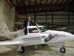
Later in the day we did our calibration flight which involved climbing to 10,000 ft and performing a series of maneuvers over a pre-selected area of land that is relatively free of mineral deposits. The problem was there was a lot of cloud in the area and we couldn't do our flying over our area at 10,000 ft and still remain clear of cloud, so we tried to improvise a bit and use the readings in the airplane to find another suitable area nearby to do our maneuvers. It was a bit of a crapshoot, but we tried it anyways since we we were already out flying, and the worse that could've happened was that the calibration wasn't up to standards and we had to go out and do it again. To our surprise our processor back in the office actually passed it and gave us the ok. Credit goes to my operator.
The survey flying has been equally hit-or-miss. Not because of weather however, but because of the raging forest fires in the area. Our morning flight yesterday was cut short after only a couple hours because smoke from fires burning nearby were both obscuring visibility and making it difficult to breath. I was doing ok for the most part, but my operator was starting to get headaches from the smoke. The afternoon flight we went to a different survey block which was a little more free of smoke, but once again cut it short as the fires burned closer and the air got thicker and thicker. We got some fantastic pictures of the fires and smoke. There was one spot where the flames were licking up WELL above the tops of the trees. I estimated they must have been at least 40 ft high at the tallest spots. You can look out over the landscape and just see hundreds and hundreds of square miles of burned out forest, as far as the eye can see. Apparently these fires have been burning all summer, and won't go out until wintertime. Fire crews are working here and there to contain what they can near the communities, the rest will just burn. This morning in our survey area most of the first seem to have died down for the most part, but there was still thick smoke in both our blocks, so we had to turn around and didn't get anything done.
I will say that the terrain we're surveying over is fantastic. Its very rocky and hilly, and lots of fun to survey, but also far more challenging then our last job, which was mostly flat swamp. There are big hills, canyons, and cliffs with differences in elevation of 100 ft or more in some places. Its beautiful. One of our survey blocks is in a bit of a valley, with big rocky hills on either ends, and a flat grassy wetland in the middle.
Another plus I like about this job is that Stony Rapids is served by an MF radio service (one step below a true Air Traffic Controller) out of Regina. So I get talk to someone when I'm coming into land and take-off, which is nice so my radio procedures don't get rusty.


Very nice blog...
ReplyDelete