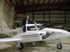
We went flying on Monday. From the heat of the day there were scattered spots of convective activity popping up all over southwestern Ontario. When you hear convective activity think potential thunderstorms. There was a line of activity north of London running from Stratford all the way to the Hamilton area, and there was also a line developing south down near Chatham as well. When I talked to the weather briefer he mentioned that London and Sarnia were ok for now but thunderstorms could easily start to pop up there as well.
We did our usual flight to Sarnia to fly some ILS approaches, and the weather turned out to be a non-event for us, as there was a wide corridor of clear skies running from Sarnia to London. But we did get to fire up our fancy stormscope which I haven't had a chance to see working yet. For those unfamiliar with such a device, a stormscope measures electrical discharges within a cloud and displays them on a little round display in the form of a green dot relative to the position of the aircraft. How it does this, the best explanation I can give is its magic, but it works. The dots once they've appeared stay on the screen in the same place until the CLEAR button is pushed. They don't move around the display if we make a turn so we have to be sure to push CLEAR everytime we make a heading change, and let the Stormscope start picking up fresh discharges again based on the new relative direction. So if there is convective activity (which produces electrical discharges) within range of our stormscope (25-200 miles depending on the setting) the little green dots on the screen will accumulate enough after a couple minutes that we can make out rather clearly where the good weather is and where the bad weather is in relation to our position. Its really quite fascinating to watch the little green dots start to pile up and clutter the display screen. We could make out very well on the stormscope the squall line over kitchener, and the stormscope also picked up the cell of thunderclouds south near Chatham quite nicely as well. Since it was a clear day we could see the Cumulonimbus clouds building in the distance over Chatham, so we really didn't need a Stormscope to tell us to stay away from there, but the beauty of this instrument is if we were flying in IMC (or even just marginal VFR) and weren't able to see a great distance in front of us, we'd be able to detect any embedded thunderclouds in real time and effectively navigate around the bad spots.
There are two other types of weather detection equipment in common usage. There is the onboard weather radar, which usually has a dome mounted in the nose of an aircraft. This dome picks up the echo's of the radar signal off of any precipitation ahead of the aircraft, and can thus show you where the heavy spots of rain are, thus indicating thunderstorms. These units however are rather large, and expensive, and for the most part are only used on larger aircraft. The other type is also weather radar, but it draws its information from ground based radar stations and relayed to the aircraft by satellite. This is known as XM WX Nexrad Weather. Or just XM Weather. Or just Nexrad Weather. This type for the most part only requires a GPS unit capable of receiving it (with a small current paid subscription), and is thus relatively affordable compared to onboard weather radar, while achieving similiar results. It does have a few minor drawbacks however. Weather information on Nexrad weather is limited to the geographical regions that are covered by a working ground radar station. It is also dependant on a solid GPS signal. It also must be noted that the information given is not in real time. New radar images are transmitted to the GPS units every 15 minutes or so. This means with this system if the weather changes quickly, you'll no longer have an accurate picture, and weather can change very rapidly, especially when we're talking about thunderstorms.
The pros to weather radar of any type is that it is more useful all year round, and it will pick up precipitation of any kind - rain, snow, freezing rain. That is something our Stormscope cannot do. Save from installing a $30,000 onboard weather radar system in our little Twin Comanche - impractical if no impossible - it gives us some pretty good capability. It shows us a clear picture of up-to-the-second dangerous weather in real time, without being dependant on technology outside of the cockpit. Pretty dang cool if you ask me.
Tuesday, March 27, 2007
Little green dots
Labels:
convection,
cumulonimbus,
flying,
IFR,
stormscope,
strikefinder,
thunderstorms,
Twin Comanche
Subscribe to:
Post Comments (Atom)


No comments:
Post a Comment