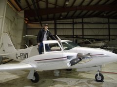
We have a short survey to do up in Kuujjuaq, QC. For those who don't know where that is, its on the southern tip of Ungava Bay in Northern Quebec. Its really a bad time of year to go up and do a survey there, but our client is in a bind, so we're going up anyways. It has not been a good start. We got out of Toronto ok, and met up with the 206 crew in Val-d'or for the night, as they had some parts in the van that we needed to take with us. The next day the weather was good enough to get to Chibougamau, which is only about an hour flight NE of Val-d'or, but beyond that the weather had turned sour. So we stayed here for the night. A little progress at a time is better than none. Our next hop however is going to have be in one go all the way up to Kuujjuac, which is 540 nm, or about 3.5 hrs, the only airport that is even remotely in between is La Grande-4 (CYAH) - you know, the one next to Lake Katatipawasakakamaw. Yes that is a real lake, and the spelling is correct. Anyway that's not even really a real airport, just an airstrip to service the generating station. There's certainly no Avgas available.. But it looks like we're going to be hanging out here in the "Chiboug" for a bit as the weather for the next few days is going to be crap.
We actually had a CHANCE that we could have made it into Kuujjuaq yesterday, and I'll elaborate on that in a bit, but first I'm going to change topics.
I've started reading a book recently called Bravo Two Zero. Its about a British SAS team behind the lines in Iraq, and their mission to go blow up some SCUD sites and communication lines. I'm only about a third into it now, and up until this point its just been build-up, mostly about planning the mission. He goes into excruciating detail on how they did their mission planning, and I actually find it quite fascinating to learn how they operate. He describes how they have a contingency plan for every possible scenario. If some of their guys go missing on patrol, they will rendezvous at such and such a place at such and such a time and wait for a defined period of time. If the RV isn't made by the deadline, they have further procedures laid out to follow. The order at which they exit the helicopter is preplanned so when they get dropped off they are able to follow certain procedures in case they end up unloading under fire. They even have procedures to follow in case they have a communications failure with home base - they will RV with the helicopter at a specified time and place, down to the details of how the team leader will approach the helicopter and exchange radios and the signals to be used in case the heli has an urgent message for the team leader. They have a plan for every possible scenario.
I'm sure by now some of you may see where I'm going with this. Flying is done in much the same way, especially IFR flying - every possible contingency is planned for. In IFR flying we try to plan for every possible contingency with the assumption that nothing is going to go right. With IFR of course the assumption is always that the weather will be IMC (Instrument Meteorological Conditions). So what if we have an emergency immediately after takeoff, such as an engine failure or fire, or other malfunction? Of course we won't be able to return for a landing visually, so we better already have our Nav instruments tuned so that we're ready to conduct an instrument approach to land at the airport we just departed from. That way there's no scramble to re-tune everything in what is already going to be a hectic cockpit environment.
There are also standard procedures laid out for a communications failure at any phase of the flight so that both pilot and controller already know what to expect from the other. Controllers when they issue instructions or clearances, such as a hold, they'll include a statement at the end that says, "... expect further clearance at [time] (for example 12:36)". That is more than just for the pilot's convenience, it is so that if a comm failure happens at some point following the last issued clearance, the pilot will then know for how long to continue his hold for before he can then automatically continue on to the next step, and he can do so knowing that ATC is expecting this.
Of course I also have to mention the contingencies that are in place regarding carrying extra fuel. Even though IFR flying is intended to give the ability to fly and land at your destination in bad weather, there still exists the possibility that the weather will be SO bad that we won't be able to sight the runway even if we're flying an instrument approach. In this case before we even take off we've included in our planning an alternate airport. This alternate airport must have weather that is forecast to be significantly better than what would normally considered to be IFR weather minimums. It is for this reason that the regulations state that we must carry sufficient fuel to:
1) Fly to our destination
2) Carry out an instrument approach, AND a missed approach (which is the procedure to overshoot and climb back to a safe altitude if the runway isn't visually spotted)
3) Fly to our alternate and carry out an approach there
4) Fly for an ADDITIONAL 45 minutes
These requirements are actually pretty restrictive, but its all designed so that we have a plan in place for every possible scenario, which is key in managing unforeseen circumstances that are out of our control. In Southern Ontario or most of the United States these fuel restrictions would actually be no big deal most of the time, because your options for finding an alternate are many, so chances are you'll be able to find an airport that's not too far out of your way that has good enough weather to land, and also has gas available to refuel. In the north however, airports are few and far between which means your alternate is going to be a LONG way away, and you better call first and VERIFY that they have fuel available, cause many times even though its listed as having fuel in the publications, it may be in drums. If it is you better be carrying a pump with you. Even still they may not even have some in stock. This ain't no USA where you can land anywhere and have your pick of where you buy your fuel. Planning is even more critical in remote areas like Northern Canada.
There's FAR fewer legal restrictions on VFR flight planning. We only legally require to have an extra 30 minutes of fuel onboard, and much more is left up to the pilot's best judgement in regards to how to handle communications failures and the like. This means much more freedom, but also requires an equal amount of more caution and good judgement. In our case at this moment, if we were to file IFR to Kuujjuaq, we'd be able to penetrate the weather that is grounding us right now, but we wouldn't actually be able to carry the legal minimum in fuel. At our current weight we're only able to take 5.2 hrs of fuel with us, but to file IFR we'd need 3.5 hrs to get to Kuujjuac, roughly another 0.3 to complete the approach and missed approach, and then from Kuujjuac the best alternate I can come up with at the moment that has fuel (just by taking a quick look) is 315 nm away, which is another 2.2 hrs of flying including the approach, and then add on our 45 minutes reserve fuel. That's a total required fuel load of 6.8 hrs! Almost double what we're actually going to burn, and WAY more than we can physically carry. IFR isn't always a feasible option.
Of course the flip-side is that if we fly VFR we can legally make the flight without having to have enough fuel to go somewhere else - that's a big extra freedom - but we better be dang well sure we're going to be able to land when we get there, because the fuel we'll have left in the tanks won't be enough to take us to the next nearest place that has avgas available. So its nice that we have the freedom to do that flying VFR, but it requires that we play it extra conservatively with the weather. Which brings us full circle all the way back to yesterday:
When we landed here in Chibougamau yesterday and checked the weather, the Kuujjuac weather was reporting 1 1/2 miles visibility with 400 ft vertical visibility (not a cloud ceiling but snow that was thick enough prevent visual contact with the ground above 400 ft). That's certainly not VFR. The weather forecast however was saying that by the time we got there it would have cleared up to marginal VFR weather conditions, which would allow us just enough leeway to land. BUT - without enough fuel to go somewhere else, do we put all our cards on the weather forecast and bank on it clearing up? I think not.
Friday, October 19, 2012

Monday, October 15, 2012
Oh You're a Pilot?
I just recently met a friend of my girlfriend, who had been told by her that I was a pilot and that I was leaving for deployment again shortly. We talked for a bit and she mentioned that my girlfriend had told her I was a pilot, but she was confused because she didn't understand why I would be leaving for somewhere else for a long period. To her a pilot just flies back and forth from A to B, so there would be no need for me to leave for extended periods. It was an innocent assumption made by someone who isn't aware of all the different amazing things you can do with an aircraft. You could see the light come on as I explained the type of flying I do, and why it now made sense that I leave for extended periods
Its actually a fairly common scenario: Somebody asks what I do, and I tell them I'm a pilot. Invariably the next question is "Who do you work for?". I dislike that question, as I would guess at least 95% of every other pilot out there does - we've all had it. Its an innocent question, but the chances are that whoever is asking will have never heard of the company we work for. When they ask it, they're expecting one of three answers: Air Canada, Westjet, or Porter (or insert any other well known regional airline that is common to the area). But what they don't realize is that those airlines really only represent probably less than 10% of the entire pilot workforce in Canada, and unless whoever is asking actually works in the Aviation industry, I can guarantee they've never heard of the company that comes as the answer. So I think most of my fellow aviators including myself are expecting the blank stare that comes when we answer their question.
I still haven't figured out how to best explain what I do in a succinct, clear answer. How do you explain in one or two sentences in a casual conversation what I do as a low-level geophysical survey pilot?
Sometimes I also get the question "What do you fly?" This is a little better question to ask. At least if they don't know what a Piper Navajo is I can easily explain that its a twin engine propeller plane that normally holds about 8 people. That's enough information for most people to imagine something that's pretty close to a Navajo. When I flew the 206 that was even easier, because everyone knows what a Cessna is.
And then there's the "Are you still building hours to become an airline pilot?" I usually have fun explaining that I'd NEVER want to become an airline pilot. There's so many better and more interesting options to strive for than airline flying, at least in my opinion.
Its a shame that people equate airline flying as the only pinnacle to a successful flying career, and associate flying a small single engine piston plane with a low-experience entry level job. While those both can be true - a good airline job CAN be the pinnacle of a successful flying career and flying around a small single-engine piston is OFTEN for entry level pilots, its not always the case. Some airline pilot jobs are the lowest paying jobs in the industry, and some light piston plane jobs can require some of the highest most refined skill level of any pilot. Some good examples are the small speciality flying charter companies that operate in and out of super-short unimproved strips or ski-plane operations that take hunters into and out of half-thawed lakes. They may be flying the same aircraft that a low-time private pilot would be flying, but what they do certainly takes the skill of a high-time professional.
As Aviatrix mentions, a better question to ask after you find out that someone is a pilot is not who they work for but "What kind of operation is it?" That's a question that will impress us, and we'll also enjoy talking about it.
Sunday, October 7, 2012
Courtesy. Professionalism.
Eighteen miles Northeast of the field. Two other aircraft have reported inbound already, I'm about to be the third. One will land well ahead of me, but I didn't catch the position of the other one.
Val-d'or airport is equipped with an MF radio service, which is halfway in between a tower and an uncontrolled airport. With a radio service there is at least one person, sitting somewhere, monitoring and communicating with traffic going in and out of the airport. They could actually be physically sitting in a tower at the airport, or even be located off-site somewhere. The main difference between a radio service and a control tower however is the principle that they do not provide controlling instructions to aircraft, but are only an advisory service. They are able to assist in the safe separation of aircraft as well as provide reports on current weather conditions. Sometimes they are radar equipped, like at Thompson, MB, but usually not, so they keep track of current traffic by asking for pilot position reports.
I make my report, "Val-d'or radio, this is XXX, 18 miles to the northeast of the field, 2100 ft, inbound for landing estimating the field in 8 minutes.".
I remind myself to use proper terminology and speak clearly and directly. I'm speaking English over the radio in Quebec, and even though the radio operator's english is very good, it is still clearly his second language. Radio communications can have enough clarity issues before you introduce multiple languages into the mix.
He responds and advises me of the location and estimated arrival times of the other two aircraft. The first one as expected will land well ahead of me and won't be a factor. The other one however, a Dash 8, is reporting 30-something miles north-east as well, with an estimate to the field at the same time as myself.
My spidy-sense tingles as I recognize my level of situational awareness is going to have to be elevated now that there could be a potential traffic conflict. The Dash 8 is making an approach onto the south facing runway despite the winds favouring the north direction. Its probably for instrument approach reasons. I choose to land in the opposite direction which means I'll join a straight in right-hand downwind.
The radio advisor asks me to slow it back and remain to the east to land number 2. Technically speaking since I'm the aircraft that is closer to the airport and at the lower altitude, I have the right of way to land first, but as a courtesy I comply and confirm that I'll slow it up to give way to the larger, faster, and thirstier aircraft. Not that the 206 already doesn't fly painfully slow, but its all relative. I pull the throttle back a hair and start to set up for joining my downwind leg.
I'm mid-downwind now, directly abeam the runway. From here under normal circumstances I would be on the ground in less than two minutes from now, but I know I'm probably going to have to extend my downwind a little bit for the Dash 8. Val-d'or radio advises me that the Dash 8 is now on 10 mile final. What?! Still? If his initial estimate to the field was accurate he would be just touching down by now. Its not an uncommon scenario actually - highly optimistic reports for eta to landing made by faster aircraft. Its all really a result of lazy airmanship from the pilots. The initial eta reports are made when the aircraft is in their descent phase at a high rate of speed. At 220 knots and 30 miles from the field the GPS is going to tell them they'll arrive in 8 minutes, but they're not going to be flying all the way into the airport at 220 knots. At some point between when they make that report and landing they're going to have to slow down to approach speed - 80 to 90 knots slower! As they slow down obviously their eta is going to increase significantly, which they didn't bother to account for. Meanwhile waiting for them to land, I've extended my downwind leg so far now that I've almost cleared the 5 mile control zone out the other side!
The weather was a VFR day, which for them as an IFR flight, still means they have to conform to VFR traffic rules in and around the airport. If an IFR aircraft is cleared for an approach into an airport by their IFR controller, it is still the responsibility of the aircraft to conform to the rules regarding VFR traffic separation. Unfortunately its been my experience that airliners don't tend to play nicely with VFR traffic, and they'd almost rather just pretend that we don't exist so they can continue to fly like its a purely IFR environment. In this case it seemed like they were happy to let me take the entire responsibility of getting out of their way, despite the fact that I technically had the right of way.
I could have easily landed and cleared the runway well before the Dash 8 if they had made a proper eta report, because I was actually almost 5 minutes ahead of them. But now I'm forced to go way out of my way as a courtesy to them. The least they could have done was hurry it up a little. Finally I land, and the radio service operator thanks me sincerely for my cooperation. That dissolves my annoyance significantly.
Its amazing what a thank you can do, but ultimately my annoyance is not with the radio operator, as he was only operating with the information he was given, and I have only ever experienced excellent service from all of those guys/girls. It is the Jazz Dash 8 pilots who displayed lazy airmanship because of the discourteous assumption that the little guy in the Cessna will let them go first, even if they're actually 5 full minutes behind him. Next time I'm half tempted to assert my right of way to land number one, but that wouldn't be courteous, nor by extension, professional. I'm sure going to rant about it on my blog though.
Thursday, October 4, 2012
Airport Hassles
I'm just coming off a rotation from flying the 206 for the last couple weeks, its been a whirlwind of small jobs and moving on to new places. We completed the job in Gander, and since moved on the Wabush, finished that job in one flight, and we're now in Val-d'or (from henceforth to be known as Valdor since the proper spelling is incredibly annoying to type out).
Valdor is a much nicer airport to work out of compared to the last two we came from, which were both highly frustrating due to the security measures. Gander did not have ground-side access to the FBO we were stationed at, so to get out to the plane we had to call ahead for an escort, and then wait with our car outside the gate for someone to come and let us in, and then escort us in our vehicle over to the FBO.
Wabush was equally as frustrating to get airside to the aircraft, as we had to notify security and then would go out and unlock the gate for us, but the problem was that security was never around when you needed them, we once waited for a half hour wondering if security would come back to their desk just to so we could ask them to open the gate and let us out to our airplane. I'm glad both of those places were only very short surveys there.
Valdor is wonderful in comparison. They have a real FBO with friendly people who are always there, a beautiful pilot lounge, and most of all private ramp separated from the security nonsense of the airline world.
I arrived a day before my operator was able to get here on an airline service (another reason why flying a personal aircraft beats the heck out of airline travel), so rather than wait for him to get here, I figured hey, I know how to operate the survey equipment, and I know how to fly the airplane, I might as well go up and try an FOM by myself! It ended up paying off, the FOM result was a pass and by the time my operator arrived we were one step ahead of the game and all we had to do was set up our base station and we were good to survey.
Doing the job of two people in the aircraft was a little extra workload, I just had to take it slow and be deliberate in my actions to make sure I didn't miss any flying related tasks or any technical steps required to set the survey gear up for flying the FOM. After the survey gear is set up, there's isn't much else for the operator to do during the actual manoeuvres, so I could purely focus on the flying aspect.
As for now, I'm on my way back home as I write this, flying home Air Canada. The other pilot arrived yesterday, back from his vacation, so we spent the day getting him back up to speed before I handed over the airplane keys and wished them luck.
Sunday, September 23, 2012
Switch it Up
So for the time being I've switched off from the Navajo to fly the 206 for a few days while our regular 206 pilot is on vacation. The 206 was just coming out of a 100 hr inspection in Gander, and the Navajo was just heading up to Gander for its 100 hr inspection, so I hitched a ride with my AME co-worker. It was a pleasant 1 hr flight that would otherwise have been a 6 hour drive for me if the timing didn't work out perfectly like it did.
The job we have here for the 206 is only a tiny little one-flight'er. Logistically speaking things have gone fairly smoothly so far. My operator arrived, and by the next day the weather cleared up enough for us to get an FOM in. The FOM was a pass on the first try fortunately, and by day 2 despite a little bit of bad weather in the morning we were airborne by 10:30 to go get the one and only survey flight done. Five hours later, we touch back down in Gander - done and done. While it was all well and good logistically speaking - not so much for my operator. It must have been something he ate (or maybe my flying?) but he was sick the whole flight. Not much fun for him, but he's a trooper, rather than wanting to go home, he toughed it out for the whole 5 hours and we got the job done.
The flight went by fairly fast for me. The survey lines are quite short, so the constant turns keep me busy, and it was interesting scenery. The north end of the block contained a lake that was very much cottage country. I flew over a couple sitting out on the end of their dock enjoying the last sliver of summer. Each time I went over they waved. They seemed to enjoy the show, which is a change from our experience in Ireland where we had to deal with numerous complaints.
I forgot how sloppy that airplane is compared to the Navajo, or anything else really. I guess all 206's are like that though. In a previous post a few years ago I described a different 206 I flew as feeling like a "flying contraption" rather than a well refined airplane - I'd still stand by that statement. It doesn't feel crisp at all like the low wing Pipers do. Oh well, at least it looks good. This spring it got a beautiful fancy new paint job which is a nice change from the stripped down bare metal fuselage is sported for a few years.
I'm glad this is a small job. This Gander airport is ridiculous for general aviation. The Shell FBO where we are parked does not have ground side access, so every time we want to go out to our airplane we have to call them, and then wait for them to come to the gate, let us in, and then escort us in our car over to the building. It would drive me crazy if we had to do this for weeks on end for a large job.
That was yesterday. Today we're waiting around for approval from our geophysicist to demobilize, or rather mobilize to our next job - in Wabush. Unfortunately we're having issues booking a hotel room... apparently they always fill up during the week due to mining crews... not quite sure how we're going to work this one out...
Sunday, September 16, 2012
Welcome to the Show
FOMs. Every geophysical survey pilot's dread. FOM stands for Figure of Merit. Its a technical term for what is basically a flight to calibrate the data acquisition computer for the magnetic sensors. Every manoeuvre of the airplane causes reading error in the magnetic sensors, so the Figure of Merit flight is the way we teach the computer to recognize the manoeuvres of the airplane and remove them from the equation, and then prove that the calibration was successful. It involves flying a a box of 4 headings (usually N, S, E and W) and executing a number of pitch, roll and yaw manoeuvres to exacting standards. The computer then learns to recognize these manoeuvres and remove them from the equation. We then fly a second box doing essentially the same thing. It is this second box that we call the Figure of Merit, which is the proof that the calibration was successful.
That's the theory. Its always a highly delicate procedure requiring a high degree of precision from the pilots. After that we land and then hand the data over to our processor/geophysicist who then determines if the calibration was successful to the degree that is stated in the job contract. Even if we as the pilots do a good job flying the FOM, getting an acceptable result can still be a shot in the dark at times, and its not uncommon to have our first attempt fail for reasons that no one can explain. Its a highly complex, mysterious algorithm the computer uses to compute the calibration values, and sometimes it just plain doesn't work very well in the real world. To make matters worse, when its a government contract (like this one) the calibration standards are even higher, requiring a result value that is so demanding it is essentially random chance as to whether or not the computer will achieve it, even if all the conditions are perfect.
Ask how it all works and you'll see heads shake and shoulders shrug and hear words like "voodoo" and "magic", even from the experts. One of our processors has started referring to it as "FOM theatre with Chad and Charles (other pilot)", because it always seems like a big show and no one knows how its going to end or when its going to be over.
Every survey pilot dreads them. The manoeuvres themselves can be uncomfortable, like a nauseating roller-coaster ride, especially for the operators who are just the helpless passengers along for the ride. I once did 3 FOMs in 1 day, in two different airplanes. Even I could feel a tinge of nausea, and I DON'T get motion sick - EVER. And then there's the fact that it requires such focus from the pilot to perform the manoeuvres correctly and with enough precision. The whole nerve racking process of doing a flight and then waiting around to hear if the results passed or not can bring even the most steely eyed and confident pilots to their knees quivering with doubts about their ability as an airman and a survey pilot. Its like taking an exam and having no idea how you did until you get your marks back. Usually after we complete the FOM and are on our way back to land, the pilot and operator try to offer words of encouragement, "I think that was good, don't you?"
"Ya I'd say so, it looked good to me..."
But really we have no idea. Not until we get the data back to the processor and he has time to look it over and do the math. FOM theatre. Its time. Welcome to the show, and please take your seat.
Wednesday, September 5, 2012
Mountain Turbulence
If there's one thing a survey pilot learns about first hand more than probably any other kind of pilot its turbulence associated with mountains. The diagram below pretty much explains it better than I can. Note there is turbulent air on both sides of the mountain, but the windward side tends to be updrafts, whereas the leeward side tends to be downdrafts.

For survey pilots, often our flight profile takes us over the peak as low as 100 ft above the surface. In fact high peaks are often when we fly the lowest. It doesn't take a large mountain to generate severe turbulence and down-drafts that close to the terrain, and that height leaves little margin to react to the down-draft or manoeuvre out of it, so its important that we always remain very aware of wind conditions, especially on the leeward side. It wouldn't take much for a down-draft to drive us into the hill-side when we're climbing up the leeward side of a mountain. Climbing up the windward side can also create different problems of an illusionary nature, simply because climbing the windward side means you're flying downwind, which can decrease your climb angle and carry you into the mountain even though it looks like you should clear it - but that's a discussion for another day.
I remember I cautioned one of our pilots (who shall remain nameless) about mountain flying once. He was not new to being a pilot, in fact has more hours then me, but completely green to low level survey. He dismissed my words confidently saying that he would be concerned about weather conditions, but not about terrain that doesn't move. His statement exposed his inexperience with flying close to the ground and revealed a little of his ego in general, but it wouldn't have been fruitful for me to do anything but leave it at that.
This mountain turbulence has been a reoccurring issue for us throughout our time in Newfoundland because the terrain rises sharply to almost 1500 ft ASL right out of the ocean, and even though our survey block is mostly offshore, it overlaps land by about 3-5 km, so every line we fly involves either climbing up over the shoreline hills, or descending over it. Today was no exception. The weather was kind of a scuzzy overcast of about 4-5000 ft, isolated rain-showers, and a strong but mainly steady wind (at least over the water). We're at a section of the block where the terrain rises out of a valley very steeply - almost vertically for 1800 ft. Its quite a stunning vista actually, but not so much when you're bouncing around trying to keep the airplane level and on line. It was once of those days where you pull your seatbelt as tight as it can go.
I did not take the pictures below, but I found them from a google search on a hiking website - they are the exact area we flew over today, right down to the canyon lake (bottom photo) which we ended up flying right over. Anyone who can guess the exact area based on the pictures gets 100 points, which are redeemable towards recognition as a Canadian traveller and bragging rights.


So back to the story. As we near the end of our line the mountain ridge looms in our windscreen. Keeping the airplane on a laser-accurate flight line doesn't take the concentration that it used to when I first started flying survey, which is good because I can devote more of my cognitive abilities to deciding how to handle the approaching mountain. Our grid actually ends about 3 km before the mountains in the top picture begin, which means we're tasked with either 1) making our turn-around inside a 3 km area, 2) climbing above the mountains and making our turn-around above them, or 3) crashing into the side of them. Option 3 would make for a bad day, option 1 would be possible but very risky due to requiring high bank angles close to a wall of mountains, and in turbulence even, which is exactly when you DON'T want to be banking hard, which really only leaves option 2.
So today we were left only with the option to climb over the mountains to make our turn. Under normal conditions I could have continued a straight over climb and clear the peak by a couple hundred feet, but in today's conditions that's not much margin to leave in case we experienced a heavy down-draft. I elect to turn left and climb parallel to the hills until we're well clear of the peak, and then begin our right turn over the ridge and follow it back to re-intercept our line descending down over the ridge. Its not the most time-efficient turn, but its the safest action. Sure enough as I was paralleling the ridge on my way back to the line we experienced a small but steady down-draft right at the crest of the ridge. In level flight at higher airspeeds it didn't end up being a factor and the airplane could handle it no problem, but encountered during the climb when airspeed is slow and the airplane is already approaching the maximum climb performance, it might have been a little hairier.
Luckily we were only faced with that condition for only the last 3 lines of the flight. These ones in particular are short lines, and making efficient turns can really cut down on unproductive flight time. Hopefully the winds on our next flight will be a little calmer, or in a different direction and we won't have to go out of our way so much.
Subscribe to:
Posts (Atom)